
Trailbreaker Defines A 10 KM Copper-In-Soil Anomaly And Assays 23.71% Copper In Rock Sample At Liberty Property
September 16, 2024 – Trailbreaker Resources Ltd. (TBK.V) (“Trailbreaker” or “the Company”) is pleased to announce the results from surface sampling at the Liberty Property, central British Columbia (BC). Soil sampling defined a property-scale (~10 km in length and up to 1.8 km wide) arc shaped, copper (Cu)-in-soil anomaly (Figure 1). Prospecting near the southwestern extent of the soil anomaly resulted in rock samples assaying up to 15.62% Cu (float grab sample) and 23.71% Cu (subcrop grab sample). A continuous chip sample near these rock samples assayed 2.15% Cu over 3.0 m.
Subsequent to completion of the surface program, additional claims totalling 1,841 hectors were staked to the southwest to cover the open-ended soil anomaly and the strike extent of the high-grade copper mineralization. Results from this surface program are being utilized in the preparation and design of a new area-based permit application for Liberty, which will allow for advanced exploration beyond the limited area drilled in the spring.
Message from the President
“This surface program has demonstrated that there is a very large area of prospective geological setting at Liberty. It is clear that the drilling conducted in the spring tested only a small area within this large anomaly. High grade copper values from sampling provide further evidence of the potential for high-grade zones within the mineralized system. Results to date at Liberty show many similarities to early exploration results at the Gibraltar Mine, where a large low-grade copper – molybdenum (Cu-Mo) system is accentuated by zones of high-grade Cu-Mo mineralization.” -Daithi Mac Gearailt
High-Grade Copper
Prospecting in the southwestern portion of the property returned numerous rock samples with >1% Cu. including 23.71% Cu from a malachite vein striking 140° – 320° (Figure 2). This area displays iron-carbonate, talc, and actinolite alteration along the contact between ultramafic rocks to the northeast and an argillite unit to the southwest. This contact was also identified in outcrop 900 m to the northwest, with similar iron-carbonate alteration and elevated Cu values (up to 0.23% Cu in float around the contact). The Cu-in-soil anomaly is particularly strong along this contact and extends to the northeast, with an average width of 1.8 km.
The malachite mineralization in the southwest Liberty property area shares similarities with the highest-grade mineralization encountered from the Spring, 2024 drilling which returned 34.2 m* of 0.47% Copper Equivalent** (CuEq), including 5.9 m of 2.02% CuEq, in hole LIB24-003. The high-grade mineralization in LIB24-003 is located along the contact of a granodiorite intrusion with ultramafic rocks. This high-grade interval is part of a wider interval of mineralized granodiorite (194.3 m of 0.16% CuEq). In the southwestern area, where the high-grade malachite was sampled, mineralization also occurs along the contact of ultramafic rocks with the argillite unit, which display similar iron-carbonate, talc and actinolite alteration. This near-surface high-grade mineralization may be associated with a mineralized intrusion, similar to that encountered in drilling.
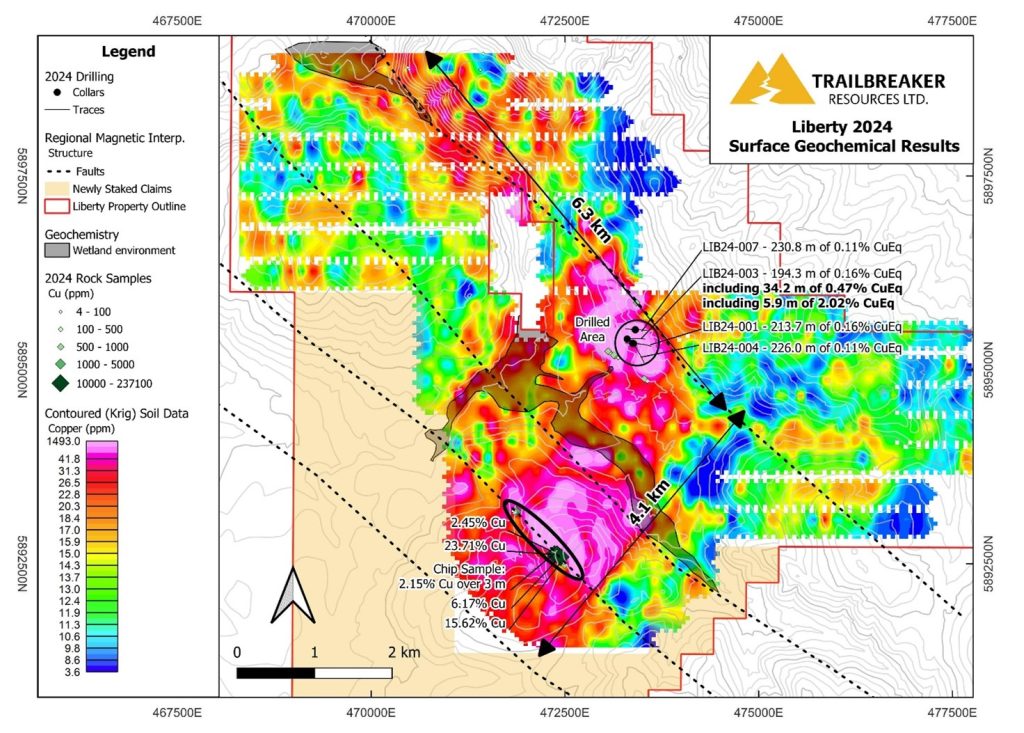
Figure 1: Contoured Cu-in-soil data across the Liberty property, highlighting the extensive property scale area of high mineral potential. High-grade Cu-bearing grab and chip samples in the southwestern area occur along a structural break (dashed lines are inferred faults are based on regional magnetic data) between ultramafic rocks to the northeast and argillites to the southwest. Wetland conditions defined by areas of deeper organic material and of high, near-surface groundwater content are outlined in the central and northern portions of the surveyed area. These soil conditions may result in locally subdued geochemical responses.
* Reported widths are drill width. Not enough geological information exists at this point to define true width. However, vein- hosted copper and molybdenum mineralization commonly occurs at high angles to core axis.
** Copper Equivalent formula used is:
CuEq = Cu grade in % + (Mo grade in % * (Mo recovery/Cu recovery) * (Mo price/lb*2200 lb) / (Cu price /lb*2200 lb) using copper price of US$3.75/lb and molybdenum price of US$25/lb. 100% metallurgical recoveries are assumed for both metals.
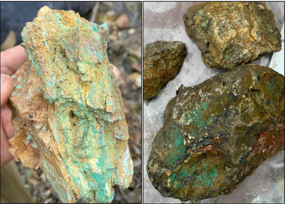
Figure 2: Photos of malachite mineralization along the contact between argillites and ultramafic rocks. Left: Grab sample from subcrop 1879956 assayed 23.71% Cu. Right: Grab sample from float 3831604 (~60 m southeast of sample 1879956) assayed 15.62% Cu.
Surface Sampling Program
Soil sampling and prospecting were designed to cover prospective geological and regional structural settings across the entire property. A total of 1,601 soil samples and 47 rock samples were collected. Cu-in-soil values are anomalous through an arcuate zone that transects the center of the property. This zone extends northeast for 4.1 km (~1.8 km width) from the southwestern limit of sampling to the centre of the property. From there, it extends northwest for an additional 6.3 km (~1.0 km width) to the northern property boundary.
This extensive Cu-in-soil is locally coincident with anomalous gold (Au), silver (Ag), molybdenum (Mo), and arsenic (As) values, defining more constrained multi-element soil anomalies. The most significant of these occur in the southwestern area, the area of Spring, 2024 drilling, and the northern area. The multi-element anomalies align well with the highest Cu-in-soil anomalies.
Two areas within the soil survey are marked by wetland conditions, with deeper organic horizons and shallow groundwater levels with water-saturated soil. These areas may cause a subdued geochemical response in soil, as the soil development has occurred in a different environment than elsewhere on the property. They are outlined in Figure 1, and occur in the central and northern boundary areas of the property.
Liberty Property Description
The 6,895-hectare Liberty Property is located approximately 60 km northwest of Quesnel, BC. The property is fully accessible by resource roads.
Drilling at Liberty has encountered widespread Cu-Mo porphyry-style mineralization at the northeastern margin of a large Cu-in-soil geochemical anomaly. Mineralization is coincident with an Induced Polarization (IP) chargeability feature. However, historic IP surveying covered only a small portion of the much larger geochemical anomaly. Highlights of drill results include: 34.2 m of 0.47% CuEq, including 5.9 m of 2.02% CuEq in LIB24-003; 13.5 m of 0.33% CuEq, including 6.6 m of 0.67% CuEq in LIB24-001; and 6.0 m of 0.45% CuEq and 2.3 m of 0.36% CuEq in LIB24-004.
Prospecting within the southwestern portion of the property-scale geochemical anomaly has defined an area of high-grade copper mineralization, with grab samples assaying up to 23.71% Cu.
For more information on this target see the Liberty Project webpage.
About Trailbreaker Resources
Trailbreaker Resources is a mining exploration company focused primarily on mining-friendly British Columbia and Yukon Territory, Canada. Trailbreaker is committed to continuous exploration and research, allowing maintenance of a portfolio of quality mineral properties which in turn provides value for shareholders. The company has an experienced management team with a proven track record as explorers and developers throughout the Yukon Territory, British Columbia, Alaska and Nevada.
ON BEHALF OF THE BOARD
Daithi Mac Gearailt
President and Chief Executive Officer
Carl Schulze, P. Geo., Consulting Geologist with Aurora Geosciences Ltd, is a qualified person as defined by National Instrument 43-101 for Trailbreaker’s BC and Yukon exploration projects, and has reviewed and approved the technical information in this release.
Other
For new information about the Company’s projects, please visit Trailbreaker’s website at TrailbreakerResources.com and sign up to receive news. For further information, follow Trailbreaker’s tweets at Twitter.com/TrailbreakerLtd, use the ‘Contact’ section of our website, or contact us at (604) 681-1820 or at info@trailbreakerresources.com.
Neither the TSX Venture Exchange nor its Regulation Services Provider (as that term is defined in the policies of the TSX Venture Exchange) accepts responsibility for the adequacy or accuracy of this release.
Forward-Looking Statements
Statements contained in this news release that are not historical facts are “forward-looking information” or “forward-looking statements” (collectively, “Forward-Looking Information”) within the meaning of applicable Canadian securities legislation and the United States Private Securities Litigation Reform Act of 1995. Forward-Looking Information includes, but is not limited to, disclosure regarding possible events, conditions or financial performance that is based on assumptions about future economic conditions and courses of action; expectations regarding future exploration and drilling programs and receipt of related permitting. In certain cases, Forward-Looking Information can be identified by the use of words and phrases such as “anticipates”, “expects”, “understanding”, “has agreed to” or variations of such words and phrases or statements that certain actions, events or results “would”, “occur” or “be achieved”. Although Trailbreaker has attempted to identify important factors that could affect Trailbreaker and may cause actual actions, events or results to differ materially from those described in Forward-Looking Information, there may be other factors that cause actions, events or results not to be as anticipated, estimated or intended. In making the forward-looking statements in this news release, if any, Trailbreaker has applied several material assumptions, including the assumption that general business and economic conditions will not change in a materially adverse manner. There can be no assurance that Forward-Looking Information will prove to be accurate, as actual results and future events could differ materially from those anticipated in such statements. Accordingly, readers should not place undue reliance on Forward-Looking Information. Except as required by law, Trailbreaker does not assume any obligation to release publicly any revisions to Forward-Looking Information contained in this news release to reflect events or circumstances after the date hereof or to reflect the occurrence of unanticipated events.