September 14, 2022 – Trailbreaker Resources Ltd. (TBK.V) (“Trailbreaker” or “the Company”) is pleased to announce the results of the Phase 1 exploration program at its 100%-owned Eakin Creek property in south-central British Columbia (BC). A 1,000 x 600-metre area has been defined as having a gold-in-soil anomaly coincident with an Induced Polarization (IP) geophysical anomaly. Also, widespread gold mineralization in bedrock and float samples was identified.
The 2022 program utilized multiple exploration tools including:
- A 302-sample Mobile Metal Ion (MMI) soil survey,
- A 10.75 line-kilometre IP survey,
- Reconnaissance prospecting and geological investigation.
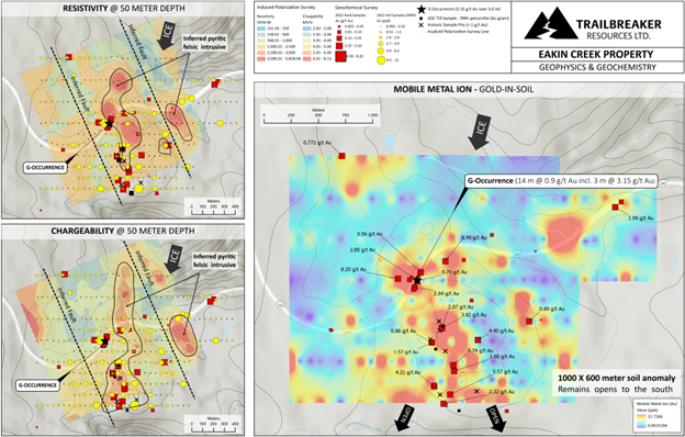
The MMI survey defined a 1,000 x 600 metre Au-Ag-Cu-Sb (gold-silver-copper-antimony) anomaly that is open to the south. This anomaly is coincident with resistivity and chargeability anomalies defined by the IP survey, which is strongest at 50 to 100m of depth.
Prospecting has identified gold-bearing mineralization hosted by two main lithologies (expanded upon below), with the majority of mineralized samples occurring within the geochemical and geophysical anomalies. Grab samples from bedrock returned assay values up to 8.2 g/t Au and 130 g/t Ag from separate outcrops more than 1 km apart.
Daithi Mac Gearailt, CEO of Trailbreaker, commented: “When Trailbreaker generated the Eakin Creek target earlier this year, it had all the indications for discovery potential: some of the highest gold-in-till values from regional till sampling in BC, high-grade rock float samples, and a compelling historic chip sample taken along the highway cut. We looked at which exploration techniques were missing, and what tools we could use to vector in to large mineralized systems potentially hidden under the till. Combining two common exploration tools that had never been done here – MMI and IP – along with Trailbreaker’s seasoned prospectors, we now have the data and results to confidently plan an exploratory drill program at Eakin Creek.”
Gold mineralization at the Eakin Creek property was found to be hosted in two distinct lithologies:
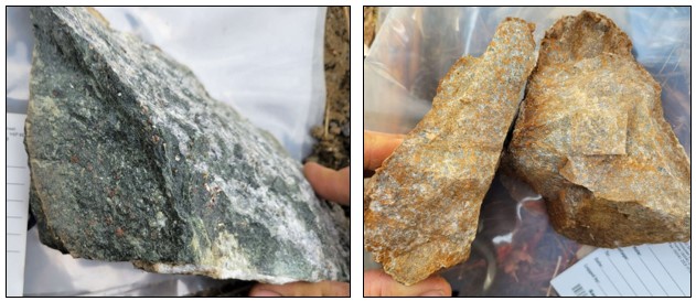
- An altered diorite unit with disseminated pyrite and quartz-carbonate-pyrite veining (Photo 1). This unit outcrops along Highway #24 which bisects the property. Assays from outcrop grab samples returned values up to 2 g/t Au and 17.0 g/t Ag from the vicinity of the historic ‘G Occurrence’. Grab samples from an outcrop located 1.0 km east-northeast of the G Occurrence (outside of the bounds of the IP survey) returned assays up to 1.1 g/t Au and 130 g/t Ag. The dioritic lithology is host to abundant quartz-calcite veining along multiple orientations. Disseminated pyrite occurs throughout the wallrock, as well as in the veins. This diorite unit is part of the early Jurassic Polaris ultramafic suite. It is bound to the west by a fault contact with similarly-aged granites of the Thuya Batholith (see Geology map).
- A limonitic felsic intrusive unit with disseminated and massive pyrite (Photo 2). This rock type has not been observed in the very limited outcrop exposure on the property; rather it is most commonly found within a boulder field approximately 400 x 300 metres in area. Grab samples from this lithology returned assay values up to 6 g/t Au and 30.7 g/t Ag (from separate samples), with six samples assaying >1.0 g/t Au. This boulder field is located ‘down-ice’ (along the direction of documented glacial ice flow) of the zone of highest resistivity identified from the IP survey (see Figure 1 below, or click link). As this felsic lithology would likely have a more resistive signature than the dominant diorite lithology, Trailbreaker geologists have determined the strongly resistive zone to be a likely source of these mineralized boulders.
Prospecting also uncovered a third, less common style of gold mineralization: quartz boulders bearing galena, chalcopyrite, and pyrite. These boulders were limited to a 5-metre area and are sub-rounded in shape. Assays returned values up to 4.2 g/t Au and 50.1 g/t Ag.

Photos 1 (left): Disseminated pyrite within a diorite unit outcropping along the highway. Assays returned values up to 8.2 g/t Au and 130 g/t Ag. Photo 2 (right): Limonitic felsic intrusive float with up to 10% pyrite. This unit is found as float within a 400x300m boulder field. Assays from the felsic rock returned values up to 5.6 g/t Au and 30.7 g/t Ag.
The highest gold grades occurring within the diorite unit were found 90m northwest of the historic ‘G Occurrence’, which consists of a 3.0 m chip sample interval grading 3.15 g/t Au, within a 14.0 m interval grading 0.9 g/t Au.
Despite the historic mineral occurrences and its proximity to infrastructure, the Eakin Creek property has never been drilled. A permit application to conduct a drill program has been submitted to the BC EMLI (Ministry of Energy, Mines and Low Carbon Innovation) and is pending approval. Trailbreaker geologists are currently planning drill targets at three areas of heightened interest:
- The historic “G Occurrence” and associated mineralized outcrops
- The zone of strongest chargeability and resistivity (north of Highway #24)
- The felsic intrusive boulder field and strongest soil geochemical gold anomaly

Figure 1: Eakin Creek property IP and geochemical results. Resistivity and chargeability at 50m (left) and gold in soil (right) with overlaid rock grab sample. Link to full size.
More about the Eakin Creek property
The Eakin Creek property is located 100 kilometres north of Kamloops, BC and can be accessed via Highway #24 and by well-maintained forest service roads (see Location map). The property covers 1,610 hectares of prospective ground that drains into placer gold-bearing Eakin Creek. The property lies in an underexplored portion of the Quesnel tectonic terrane which hosts many of BC’s producing copper and gold mines, such as the New Afton, Ajax, Mt Polley, Highland Valley, and Copper Mountain mines. The claim package is 100%-owned by Trailbreaker Resources with no underlying royalties or payments.
A regional-scale till sampling survey conducted by the Geological Survey of Canada has shown that this underexplored portion of the Quesnel terrane has an anomalous Cu-Au-As-Mo geochemical signature that is indicative of copper porphyry environments elsewhere in BC. Furthermore, some of BC’s highest gold grain-count values are recorded from till samples from the Eakin Creek property (see Regional Till Survey map).
Placer gold was first discovered in Eakin Creek in the late 1800s, with small scale placer mining occurring through to the 1940s. The hard rock source of the placer gold remained a mystery for over 100 years. Gold in bedrock was first discovered on the property in 1983 during the construction of Highway #24, with subsequent hard rock discoveries continuing through to the early 1990s.
Prospecting and trenching have proved difficult in the area due to widespread glacial till cover; however, the limited historical exploration completed to date has been successful in determining the sources of gold-in-soil anomalies. Numerous high-grade float rock grab samples have been obtained from surficial pits, assaying up to 2.60 oz/ton (89.13 g/t) Au and locally containing visible gold. Historic outcrop sampling returned a 3.0 m chip sample interval grading 3.15 g/t Au, within a 14.0 m interval grading 0.9 g/t Au (see Historic Rock Geochemistry map).
Until 2022, no IP surveys had been conducted on the property. No drilling has ever been conducted on the property.
For more details and maps on Eakin Creek see the dedicated section on Trailbreaker’s website.
Message from the President
“The Eakin Creek property has quickly become one of our most exciting assets. It’s all here: the gold, the access, and the infrastructure. The logical next step is to get some hard data from the subsurface. Stay tuned for further updates.”
ON BEHALF OF THE BOARD
Daithi Mac Gearailt
President and Chief Executive Officer
OTHER
Rock sample analysis and assaying were conducted by Bureau Veritas Mineral Laboratories Canada in Vancouver, BC, which is an ISO-17025 accredited laboratory. Rock samples were crushed, split and pulverized to a 250 g pulp passing through a 200-mesh screen (prep code PRP70-250). For gold analysis, a 50 g split underwent fire assay with an ICP-ES finish (FA350-Au). Samples assaying >10 ppm Au were re-analyzed with a gravimetric finish (FA550-Au). Samples also underwent 37-element analysis involving aqua regia digestion and ICP-ES/MS analysis (AQ200).
Soil sample analysis was conducted by SGS Laboratories Canada in Vancouver, BC which is an ISO-17025 accredited laboratory. Mobile Metal Ion (MMI) technology was used, analysing for 53 elements. Target elements were extracted using weak solutions of organic and inorganic compounds, rather than by conventional acid-based digestion. Analysis was done on a 50 g sample, and the extracted solution was analyzed by ICP-MS.
Trailbreaker Resources employs rigorous quality assurance procedures regarding sample collection, chain of custody and data entry. The reader is cautioned that grab samples are single rock samples that are typically, but not exclusively, constrained to mineralization. Grab samples are selective in nature and collected to determine the presence or absence of metal values. These do not necessarily provide an accurate representation of the tenor of the targeted zone sampled.
Carl Schulze, P. Geo., Consulting Geologist with Aurora Geosciences Ltd, is a qualified person as defined by National Instrument 43-101 for Trailbreaker’s BC and Yukon exploration projects, and has reviewed and approved the technical information in this release.
For new information about the Company’s projects, please visit Trailbreaker’s website at TrailbreakerResources.com and sign up to receive news. For further information, follow Trailbreaker’s tweets at Twitter.com/TrailbreakerLtd, use the ‘Contact’ section of our website, or contact us at (604) 681-1820 or at info@trailbreakerresources.com.
Neither the TSX Venture Exchange nor its Regulation Services Provider (as that term is defined in the policies of the TSX Venture Exchange) accepts responsibility for the adequacy or accuracy of this release.
Forward-Looking Statements
Statements contained in this news release that are not historical facts are “forward-looking information” or “forward-looking statements” (collectively, “Forward-Looking Information”) within the meaning of applicable Canadian securities legislation and the United States Private Securities Litigation Reform Act of 1995. Forward-Looking Information includes, but is not limited to, disclosure regarding possible events, conditions or financial performance that is based on assumptions about future economic conditions and courses of action; expectations regarding future exploration and drilling programs and receipt of related permitting. In certain cases, Forward-Looking Information can be identified by the use of words and phrases such as “anticipates”, “expects”, “understanding”, “has agreed to” or variations of such words and phrases or statements that certain actions, events or results “would”, “occur” or “be achieved”. Although Trailbreaker has attempted to identify important factors that could affect Trailbreaker and may cause actual actions, events or results to differ materially from those described in Forward-Looking Information, there may be other factors that cause actions, events or results not to be as anticipated, estimated or intended. In making the forward-looking statements in this news release, if any, Trailbreaker has applied several material assumptions, including the assumption that general business and economic conditions will not change in a materially adverse manner. There can be no assurance that Forward-Looking Information will prove to be accurate, as actual results and future events could differ materially from those anticipated in such statements. Accordingly, readers should not place undue reliance on Forward-Looking Information. Except as required by law, Trailbreaker does not assume any obligation to release publicly any revisions to Forward-Looking Information contained in this news release to reflect events or circumstances after the date hereof or to reflect the occurrence of unanticipated events.
